Current Projects
Heterogeneities of the Alaska Megathrust: From the Overriding Plate to the Subducting Slab

The Alaska Peninsula, a region known for its seismic activity, has captured the attention of scientists as a key area to study fundamental questions about subduction processes. Subduction, where one tectonic plate moves beneath another, can lead to large magnitude earthquakes. The Alaska Peninsula has a history of such events, making it an ideal location to explore the relationship between different geological features of the overriding and subducting plates and these earthquakes. Recent community seismic experiments have provided high-quality data from this region. This project will allow researchers to utilize this data to better understand the structure of the Earth's plates in this region. This will in turn allow testing hypotheses related to how structures in the overriding plate may influence earthquake processes. This research not only benefits Alaska but contributes to a global understanding of earthquake processes, ultimately helping us better prepare for and mitigate earthquake hazards at subduction zones. This is a collaborative project with Shawn Wei at MSU.
This project is funded by NSF Award # 2330938.
Constraining Transcrustal Magmatic Systems with Receiver Functions Along the Aleutian Island Arc

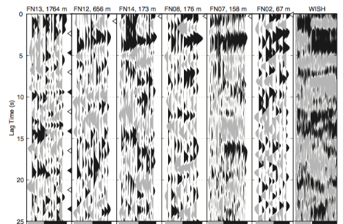
The subterranean plumbing system beneath volcanoes is still not well understood. Recent advances in the understanding of crustal magmatic storage reveal them as complex, multi-layered systems consisting of both melt and crystal mush. However, it remains unclear how magma is stored and transported from the Earth’s mantle through the crust at volcanic arcs. A volcanic arc is a chain of volcanoes located above a subducting tectonic plate, i.e., a plate diving underneath another. Magmatic systems at arc volcanoes are a critical link between the subducting slab and the shallow magma reservoirs that feed volcanic eruptions. However, many established methods of constraining depth of magma storage have relatively low resolution in the mid-to-deep crust. Receiver functions are a technique of seismic imaging relatively underutilized in volcanic settings. They have recently shown promise in their ability to image magma storage in the deep crust. Here, we apply this technique to image the magmatic system beneath volcanoes in the Aleutian Island arc, in Alaska. This study also contributes to developing an imaging technique that can be applied to other volcanoes around the Globe.
This project is funded by NSF Award # 2052829.

Since August 2019 the Pāhala region has been experiencing an elevated swarm of deep seismicity (> 20 km depth). It is currently one of the most seismically active regions on the Big Island of Hawaiʻi, and it is of continued concern to residents and emergency managers in the region. The increase of the rate of seismicity since has renewed scientific interest in implications for deep magma supply. While the ongoing seismic swarm is well characterized by the HVO seismic network, independent seismic velocity constraints can provide additional information on the potential presence of magmatic storage or transport at depth in this region. To address this gap, we will calculate a seismic receiver function profile along a transect within the current Pāhala swarm.
This project is funded in collaboration with the Hawaiian Volcano Observatory USGS, and is a collaboration with Dr. Ninfa Bennington at HVO.
Janiszewski, H. A., N. Bennington, J. Wight, (2024), A Seismic Nodal Deployment to Understand Magmatic Structure in the Vicinity of the Pāhala Earthquake Swarm, Seismological Research Letters, doi: https://doi.org/10.1785/0220240060
Media and Press Releases:
05/12/22: Using Earthquakes to Look Under the Hood at Pāhala, Volcano Watch
06/13/22: Seismic Nodes Deployed Along Kīlauea Southwest Rift Zone, Big Island Video
09/09/22: Recovery of Seismic Nodes From Kīlauea Southwest Rift Zone, USGS News
News
6/30/22: UH research investigates increase in Pāhala earthquakes
SMART Subsea Cables: Implementing for Geophysics, Early Warning, and Oceans, Vanuatu-New Caledonia to Global

This project is led by Dr. Bruce Howe in the Department of Ocean Resources and Engineering at University of Hawaiʻi at Mānoa, and is funded by the Gordon and Betty Moore Foundation. It is an international, multi-institutional, collaborative project. More information can be found here.
Rowe, C. A., B. M. Howe, M. Fouch, M. Angove, J. Aucan, C. R. Barnes, J. Barros, N. Bailiff, N. C. Becker, F. Carrilho, B. Fry, A. Jamelot, H. A. Janiszewski, L. S. L. Kong, S. Lentz, D. S. Luther, G., Marinaro, L. M. Matias, A. Salaree, A. Sakya, T. Theile, F. J. Tilmann, C. von-Hildebrandt-Andrade, L. Wallace, S. A. Weinstein, W. Wilcock (2022), SMART Cables Observing the Oceans and Earth, Marine Technology Society Journal, 56, 5, pp. 13-25, https://doi.org/10.4031/MTSJ.56.5.3
Howe, B. M.,M. Angove, J. Aucan, C. R. Barnes, J. Barros, N. Bayliff, N. C. Becker, F. Carrilho, M. Fouch, B. Fry, A. Jamelot, H. A. Janiszewski, L. S. Kong, S. Lentz, D. S. Luther, G. Marinaro, L. M. Matias, C. A. Rowe, A. Salaree, A. E. Sakya, T. Thiele, F. Tilmann, C. von Hillebrandt-Andrade, L. Wallace, S. Weinstein, W. Wilcock (2022), SMART Subsea Cables for Observing the Earth and Ocean, Mitigating Environmental Hazards, and Supporting the Blue Economy, Frontiers in Earth Science
Automated Tilt and Compliance Removal

Comparison of an earthquake recorded prior to and after compliance corrections on an OBS.
Janiszewski, H. A., Z. Eilon, J.B. Russell, B. Brunsvik, J.B. Gaherty, S. Mosher, W. Hawley, S. Coats, (2023), Broad-Band Ocean Bottom Seismometer Noise Properties, Geophysical Journal International, ggac450, https://doi.org/10.1093/gji/ggac450
Mosher, S. G., Z. Eilon, H. A. Janiszewski, P. Audet (2021), Probabilistic inversion of seafloor compliance for oceanic crustal shear velocity structure using mixture density neural networks, Geophysical Journal International
Janiszewski, H. A., J. B. Gaherty, G. A. Abers, H. Gao, Z. Eilon (2019), Amphibious surface wave phase velocity measurements of the Cascadia subduction zone, Geophysical Journal International.
Past Projects
Plate Boundary Structure and Deformation Workshop

Participants for an interdisciplinary networking session (photo credit Z. Eilon).
We hosted a 2-day workshop, with a half-day early career pre-workshop meeting at the University of Hawaiʻi at Mānoa from March 16 - March 18, 2022. This was a GeoPRISMS Funded synthesis workshop focused on the following questions: (1) What are the relationships between fault zone rheology and deformation and how are they constrained across a range of temporal and spatial scales in the field and lab? (2) How does the rheology of the crust and mantle influence and/or record deformation at plate boundaries? (3) What feedbacks exist between larger scale lithospheric processes, fault zone rheology, and surface processes? More information can be found at the workshop website.
This workshop was supported by NSF Award #2025668.
Magma Storage in the Deep Crust Beneath Cleveland Volcano

Variation in average crustal shear velocity beneath Cleveland Volcano.
Crustal magmatic structure beneath volcanoes is difficult to seismically image, particularly in the mid- to deep-crust. Receiver functions provide an opportunity to observe low velocity regions likely associated with partial melt/mush, elevated temperatures, or altered material within the crust at these depths without the need for a high-density, large-aperture broadband seismic array. Our results at Cleveland Volcano in the central Aleutian island arc, one of the more active volcanoes in the region, shows evidence for an extensive crustal magma body, extending to depths greater than 10 km, likely indicating a transcrustal magmatic storage region at this open system volcano.
Portner, D. E., L. S. Wagner, H. A. Janiszewski, D. C. Roman, J. A. Power (2020), Ps-P tomography of a mid-crustal magma reservoir beneath Cleveland Volcano, Alaska, Geophysical Research Letters
Janiszewski, H. A., L. S. Wagner, D. C. Roman, (2020) Aseismic mid-crustal magma reservoir at Cleveland Volcano imaged through novel receiver function analyses, Scientific Reports
Lithospheric and Plate Interface Structure of the Cascadia Subduction Zone

Phase velocity map for Cascadia.
Example of P-to-S receiver functions calculated from OBS instruments.
Janiszewski, H. A., J. B. Gaherty, G. A. Abers, H. Gao, Z. Eilon (2019), Amphibious surface wave phase velocity measurements of the Cascadia subduction zone, Geophysical Journal International.
Till, C. B., A. Kent, G. A. Abers, H. A. Janiszewski, J. B. Gaherty, B. Pitcher, (2019) The Causes of Spatiotemporal Variations in Erupted Fluxes and Compositions Along a Volcanic Arc, Nature Communications.
Crosbie, K. J., G. A. Abers, M. E. Mann, H. A. Janiszewski, K. C. Creager, C. Ulberg, S. Moran, (2019) Shear velocity structure from ambient noise and teleseismic surface wave tomography in the Cascades around Mount St. Helens, Journal of Geophysical Research
Janiszewski, H. A., G. A. Abers, (2015) Imaging the plate interface in the Cascadia seismogenic zone: New constraints from offshore receiver functions, Seismological Research Letters.
Crustal Structure of the Aleutian Island Arc
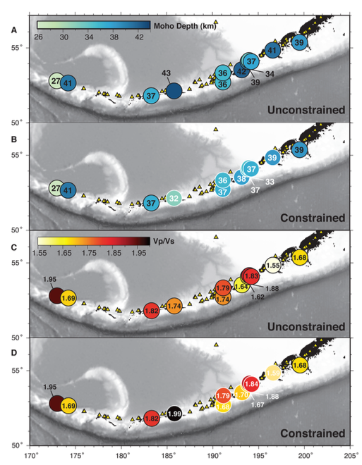
Depth to Moho and average crustal Vp/Vs along the Aleutian arc.
Janiszewski, H. A., G. A. Abers, Shillington, D.J., and J. A. Calkins, (2013) Crustal structure along the Aleutian island arc: New insights from receiver functions constrained by active source data, Geochem. Geophys. Geosys